What to see
The Namib desert, the oldest desert in the world, is strewn with gorges and canyons, among others Sesriem and Kuiseb canyons. The colours of the dunes, especially at sunrise and sunset, the harmony and uniqueness of so many places, make it a must to spend some time in the Namib desert for anyone who truly wishes to discover Namibia.
The red sand is transported by the Orange river to the ocean, it is then carried Northwards by the Benguela current, and left along the coast. Over time, the dunes of the Namib were sculpted by the wind, creating strange and complex silhouettes. This seemingly arid landscape is in fact a complex ecosystem which can survive only because of the humidity brought by the precious mists that come in from the Atlantic Ocean.
- Sossusvlei / Sesriem
- Swakopmund and Walvis Bay
- Cape Cross
- The Skeleton Coast
- Kuiseb
- Naukluft mountains
- Fish River Canyon
- Lüderitz
- Etosha National Park
- Damaraland
- The White Lady
- Petrified Forest
- The Brandberg
- Spitzkoppe
- The Kaokoveld
- Lake Otjikoto
Sossusvlei / Sesriem
170 km to the South (about 2 hours’ drive depending on the road conditions) lies the magnificent Red Dune Sea of the Namib.
Sossusvlei an old diamond-mining area, opened to the public 20 years ago. With a height of up to 300 m, and with phenomenal colours, richer and more subtle than any artist’s pallet, Sossusvlei is a MUST See on your visit to Namibia.
As you drive from the Sesriem gate into the park, via the 60km tarred road, you pass the Sesriem Canyons, this Gorge has a wonderful story and the Tsauchab river runs through the Canyons all the way to the Deadvlei in exceptionally good rainy seasons.
A few kilometres from the end of the road you will find DUNE 45, one of the more accessible dunes in Sossusvlei, The view from the top will make it worth the climb. Wear closed shoes and take enough water.
Once you have reached the end of the tarred road, you can only continue with a 4x4 vehicle. Engage 4-wheel drive and follow the tracks of the other vehicle for 5km to the DEADVLEI Parking. You can also make use of one of the Shuttles if you do not feel up to driving the 4x4 route yourself.
From there you walk about 1,1km over the dunes to reach Dead Vlei, one of the most magical places on earth. It used to be a lake that dried out hundreds of years ago. Try to do this early morning or late afternoon to avoid the Extreme heat during midday. Again, take enough water.
Swakopmund and Walvis Bay
Swakopmund, Namibia’s second biggest town and traditional “summer capital”, is one of the most surreal places in this country. You approach the town through the endless expanses of the Namib Desert, one of the world’s largest wilderness areas. Then, through the mists (it is almost always misty in the morning and late afternoon) Bavarian spires and elaborate Germanic architecture rise through the fog banks. The boom of the surf on the notorious Skeleton Coast is an ever-present reminder of the icy Atlantic Ocean beyond. The town is an eclectic mixture of Bohemian and Bavarian, home to an intriguing mix of artists, hippies, strait-laced descendants of German settlers, stately Herero women in Victorian dress, and hard bitten miners, game rangers, safari operators and fishermen. Swakopmund exudes romance and history, a rich cultural melting pot of old and new.
Night time entertainment ranges from sophisticated spins on the casino’s roulette wheels, through raucous parties at the many pubs and restaurants, to an assortment of drama, music and cultural events. Once you’ve got over the shock of being in a little corner of old Bavaria wedged between one of the world’s harshest deserts and even harsher coastlines, the bewitching desert beckons. Just outside town is the extraordinary Moon Landscape, a seemingly never-ending series of bizarre hills that look like pictures taken of Mars, or the Sea of Tranquility. It is best visited at sunrise or sunset. A bit further afield, in the bed of the Khan River, is the oasis of Goanikontes, a lush splash of water and vegetation in the barren Namib. For botanists, there is the lure of the fields of what have been called “living fossils”, the giant Welwitschia mirabilis. These extraordinary trees never grow more than two meters above the ground, but the bigger specimens have underground stems which are up to four meters wide. The tree has just two leaves, which droop in opposite directions. If one of the leaves dies, the plant dies. The oldest living specimen has been dated at 2 000 years old, while the average age of the youngsters is between 500 and 600 years old.
Just outside Swakopmund, a section of towering Barchan dunes have been set aside for recreational purposes – sand boarding and skiing, quadbiking, camel rides and off-road driving. Swakopmund also offers a host of other attractions, including excursions by boat to see dolphins and seals, shorebased angling (some of the best in Africa), skin diving, surfing or just simply lazing on the beach. And, of course, the town is surrounded by the Namib Naukluft Park, one of the most bewitching desert wilderness areas in Africa, for one day trips or longer safaris for the ultimate desert camping experience.
Cape Cross
The main attraction for tourists at Cape Cross is the seal colony and an interesting history of this place.
The first European landed on Namibian soil was Portuguese explorer Diego Cao (1486) who erected the first stone cross in honor of King Johannes of Portugal. It was the tradition of the Portuguese to build a cross where ever they landed. These crosses had various functions: symbol of Christianity, documentation of the rights of possession and landmark for passing ships.
The seal colony at Cape Cross is the breeding place of the Cape fur seals, which are actually a species of sea lion. Along the Namibian and South African coast there are 24 colonies with a seal population of about 650 000 animals. At Cape Cross live about 80 000 to 100 000 seals. They are slightly reduced every year because they are still desired and apparently they eat too much fish.
Reproduction. Outside the breeding period one hardly sees any bulls in the colony. They only come in October every year to mark their territory, which they defend for life or death against other bulls. Fully grown bulls can weigh up to 190 kg but at the beginning of the breeding period they weigh up to 360 kg.
The Skeleton Coast
The attraction of this remote area lies in the colour, changing moods and untouched profile of its landscape. Its aura of mystery and mightiness is largely due to the dense coastal fog and cold sea breezes caused by the cold Benguela ocean current from the Arctic, and bones scattered on its beaches from where the park's name derives.
The landscape in the park ranges from sweeping vistas of wind swept dunes to rugged canyons with walls of richly coloured volcanic rock and extensive mountain ranges. Its level coastline characterises the park, only occasionally broken by scattered rocky outcrops. The southern section consists of the gravel plains, but north of Terrace Bay high dunes occur in the immediate vicinity of the coast.
The remains of shipwrecks scattered along the coast bear witness to many ships, which have come to grief along these desolate shores.
Kuiseb
This spectacular canyon is located on the C14 road to Walvis Bay.
The ephemeral Kuiseb is mostly a dry river bed, but in good rainy seasons can run two or three weeks and in the rare occasion reach the sea.
Naukluft mountains
The Naukluft Massif, North of Sesriem is an imposing natural barrier, a wild place with impressive gorges. Opened at first under the name Mountain Zebra, it was later regrouped with the park. A protected area since 1964, the Naukluft section of the Namib-Naukluft park stretches out on a plateau traversed by steep gorges and overhangs the vast plains that join up with the dunes along the Atlantic coast. Peaks of over 2000 meters crop up from the expanses of white and pink sand.
Over the centuries, the fauna and flora have evolved, engendering the most remarkable ways in to survive the hostilities of the Namib desert. Three age-old rivers have their source in the Naukluft mountains : the Tsondab in the North, the Tsams in the West and the Tsauchab in the South. They are generally dry except in periods of heavy rain. These rivers have cut great canyons, penetrating deeply into the dolomite formations and have thus allowed for the survival of a rich desert vegetation. These few water streams formed small de basins in which one can swim.
Fish River Canyon
The Fish River canyon, situated along the lower reaches of the Fish River, is one of the most impressive natural beauties in the southern part of Namibia. It developed predominantly during the pluvial times - rainy climatic epochs - many millions of years ago. With its depth of up to 550 meters, the Fish River Canyon is the second largest canyon in the world, following the Grand Canyon in America. The enormous gorge winds along a distance of approx. 160 kilometers through the fissured Koubis massif all the way down to Ai-Ais.
As the Fish River is dammed in Hardap, it usually carries only a small amount of water. However, after a heavy rainfall, it quickly turns into a raging torrent.
The Fish River canyon has become a popular hiking destination. Hikes require a good physical health, however, and should only be undertaken during the cooler winter months between May and September.
A permit from Nature Conservation in Windhoek must be obtained. The hike lasts for 5 days, the length is 86 kilometers. Much easier - but also very attractive - hikes are offered in the bordering private "Canyon Nature Park".
Lüderitz
Isolated, on a wind-beaten desert coast, Lüderitz surprises the visitor. Here, it seems time has stopped. Its deserted beaches are the territory of colonies of flamingos, penguins, and seals.
A little further to the North
Etosha National Park
Etosha National Park is one of Southern Africa's finest and most important Game Reserves. Declared a National Park in 1907 and covering an area of 22 270 square km, it is home to 114 mammal species, 340 bird species, 110 reptile species, 16 amphibian species and, surprisingly, one species of fish.
Etosha, meaning "Great White Place", is dominated by a massive mineral pan. The pan is part of the Kalahari Basin, the floor of which was formed around 1000 million years ago. Today, the Etosha Pan rarely has water as it is supplied mostly from rainfall but with high evaporation the water quickly disappears.
A San legend about the formation of the pan tells of how a village was raided and everyone but the women slaughtered. One woman was so upset about the death of her family she cried until her tears formed a massive lake. When the lake dried up nothing was left apart from a huge white pan.
The game viewing in Etosha is excellent, the best time being from May to September. Visitors can expect to see many buck species, elephant, giraffe, rhino and lions. More fortunate visitors will see leopard and cheetah. There is a network of roads linking the three campsites and subsidiary roads lead to various waterholes.
Damaraland
This old « homeland » is of specific interest for its: geology (impressive plateau of red granite, dry river beds...).
The main places to see are:
The pre-historic rock engravings in Twyfelfontein
Twyfelfontein - south of Khorixas - has one of the most extensive accumulations of pre-historic rock paintings in Namibia. Predominantly portrayed are lions, giraffes and elephants.
Furthermore, there are numerous abstract objects, about which no definite knowledge is available. Although the exact age of the drawings is unknown, it is estimated that they are between a few hundred and several thousand years old.
The White Lady
In the year 1918 about 100 kilometers further south in the Tsisab gorge at the Brandberg the most famous rock paintings were discovered. A well-known French historian named the painting 'the white lady'. He thought the figure resembled a lady of Greek or Egyptian origin. However, nowadays scientists agree that the painting portrays a young man. The lower part of his body is painted in white, a magical hunting spell, as was customary to the Himbas and the Hereros.
Petrified Forest
Signposted beside the C39, The Petrified Forest is a geological site situated about 50 km west of Khorixas, lie a number of petrified trees on a bed of sandstone. Some are partially buried, while others lie completely exposed because the sandstone surrounding them has eroded away. It is thought that they were carried here as logs by a river, some 250 million years ago, and became stranded on a sandbank. Subsequently sand was deposited around them, creating ideal conditions for the cells of the wood to be replaced by silica, and thus become petrified. The "forest" covers an area of about 800m by 300m and lies in the Aba Huab River valley. There are at least 50 trees, some still only partly exposed.
The Brandberg
The Brandberg ("fire mountain", "mountain of the Gods", "forsaken mountain") named for the effect created by the rising and setting sun on its faces, is a massive inselberg that dominates the surrounding rock and gravel plains. Maack's Shelter in the Tsisab ("leopard") Ravine contains the famous "White Lady" painting which has evoked a myriad hypotheses as to its origin and meaning. The figure is estimated to be over 4000 years old.
The summit of the Brandberg, Konigstein, is Namibia's highest peak at 2579m. Conquered in 1918, it provides a formidable goal for mountaineers with horrendous daytime temperatures, bitterly cold nights and a serious scarcity of water.
Spitzkoppe
The Spitzkoppe between Usakos and Swakopmund, also known as the 'Matterhorn of Namibia', rises to an altitude of about 1800 meters. The Spitzkoppe is by no means Namibia's highest mountain. However, due to its striking features and outlines, it is considered as the most famous mountain in the country.
Situated in an endless, dry landscape, the island of mountains can be seen from quite a distance. The enormous granite rocks developed more than 100 million years ago due to volcanic activities and subsequent erosional activity.Spitzkoppe is one of Namibia's most photographed sites.
Together with the Brandberg and the adjacent Erongo mountains, Spitzkoppe is the most famous mountains in the country.Travellers form all over the world come to explore Namibia and some of its fascinating destinations, such as Spitzkoppe.
You can't help, but be stunned by its natural beauty. The mountain is more than 700 million years old. In 1946 the Spitzkoppe was first climbed from its western side. Since then the Spitzkoppe remained popular for Namibian and foreign climbers. The Spitzkoppe rises about 1784 meters (5857 feet) above the flat surrounding plain.
The Kaokoveld
Originally referred to as the Kaokoland district, the remote north-western corner of Namibia is rugged, harsh, untamed and practically devoid of commercial tourist developments.
This hinterland, reached by the Herero during the early southward Bantu migrations about 450 years ago and the Dorstlandtrekkers over 120 years ago is still sparsely inhabited by man. The Himba (or Ovahimba) tribe are Herero descendants who continue their semi-nomadic existence in this primitive wilderness today.
The Kaokoveld remains a wild sanctuary for small but wide-ranging populations of the renowned desert elephant, rhino, giraffe and lion. Roads are horrendous and basic infrastructure is virtually non-existent - this is prime safari territory!
Lake Otjikoto
Another marvel of nature: lake Otjikoto, 24 km North-West of Tsumeb. The members of the Windhoek Underwater Club discovered an underwater museum which qualified divers can now explore at a depth of 55 m. Covering an area of 25 m by 5 m, armaments and weaponry dating back to the First World War can be viewed.
Near the lake you will discover the meteorite Hoba, the largest meteorite ever to have been found on earth (it weighs 80 tons and is 80 000 years old).
Side Pannel
Specials
Breaking News
Newsletter
Subscribe to our newsletter for the latest happenings and specials.
Accommodation
KuanguKuangu Romantic
For those who prefer absolute isolation, privacy, and exclusivity in Namibia and the ideal place for the traveller who seeks tranquillity and intimacy, our newly built KuanguKuangu with exquisite finishes, this is the place for you.
Barkhan dune Chalets For Friends and Family
Perfectly blending with the surrounding landscape, Gecko, Tarentaal and Bushman have single or Double Beds and a Pull Out Couch which can accommodate smaller children in the same room as their parents.
Rustic Cabin Self-catering
Nestled around a big boulder, this self-catering cabin makes it possible for its occupants to live in harmony with nature, at the same time offering them comfort, luxury, adventure and relaxation.
Activities
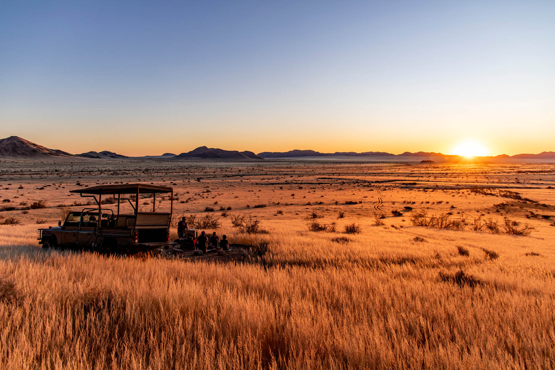
Farm Drive/Sundowner
The farm has a rich fauna and flora. At the main Building we have a resident Meerkat (des suricate), which just loves to photographed by our guests.
Birdwatching
Our two days at your lodge was one of the most memorable moments of our trips. The chalets (despite the cold water for our friends), the setting/views and the personal touch you and Nikkie give to this place were really outstanding.
Hikes & Trails
Our self-catering unit are nestled right next to the Mountain, which ensures complete privacy if so required. It cannot be seen from the main Building nor from any of the roads.
Hike to Ubib Grotto
This remarkable archaeological site is called Ubib Grotto. Go on a guided 2.5-hour excursion to the cave and be mesmerised by this special place.
